
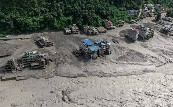
A rapidly expanding lake near the China-Nepal border is raising fears of another devastating flood after a glacier collapse created a debris barrier that is now struggling to contain rising water.
Chinese authorities have increased the flood alert around the Gyirong border port, warning that a breach could unleash a powerful surge downstream and trigger landslides, rockfalls and avalanches.
The worsening situation has also forced Chinese rescue teams to retreat from exposed areas and relocate to safer ground while engineers assess how to reduce the pressure building behind the debris barrier.
Lake Swells to More Than 2.5 Million Cubic Metres
China’s state broadcaster CCTV reported on Friday that the newly formed lake now contains more than 2.5 million cubic metres of water.
That represents a sharp increase from the estimated 1.5 million to 2 million cubic metres measured by an eight-member Chinese engineering team just one day earlier.
The lake developed upstream of the Gyirong port after a debris barrier formed following a glacier collapse.
The area was already reeling from a flash flood on Wednesday that caused extensive destruction and reportedly killed hundreds of people.
Engineers Search for a Way to Drain the Lake
An engineering team arrived on Thursday to examine the lake and determine whether the growing volume of water can be safely released.
Officials are using aerial surveys and three-dimensional modelling to map the terrain and assess possible methods for reducing pressure on the barrier.
Engineer Chen Hanxiao said the landscape itself presents a major obstacle.
Steep, isolated cliffs have formed around portions of the lake following the glacier collapse, making access and construction particularly difficult.
One option under consideration is to cut a drainage channel through a lower section of the debris barrier.
The proposed channel would allow water to escape gradually rather than waiting for the barrier to fail catastrophically.
But engineers first need to calculate the likely flow rate and determine how quickly the lake could continue filling. Those calculations will help establish the channel’s required width and depth.
Unstable Mountains Add Another Threat
The danger is not limited to the lake itself.
Authorities are watching surrounding mountain slopes for signs of landslides, falling rocks and avalanches, all of which could further destabilise the area or send additional material into the basin.
Weather conditions are another concern.
Light to moderate rain has been reported around the Gyirong border port, potentially weakening already unstable soil and rock in the upstream region.
Chinese authorities had previously estimated that as much as three million additional cubic metres of water could flow into the lake within three days.
Officials expect the largest water flow around September 1.
Lake Already About 150 Metres Long
Survey measurements indicate that the lake extends roughly 150 metres and reaches depths of between 40 and 50 metres.
Aerial images released by Chinese state broadcaster CGTN showed muddy brown water accumulating in the basin, covering vegetation and pushing against the natural wall of rocks and debris.
The growing pressure has heightened concern that the barrier could eventually fail.
Hundreds Still Missing
The disaster has also created a major humanitarian crisis on both sides of the China-Nepal border.
Hundreds of people remain unaccounted for, according to officials.
The missing include as many as 540 foreign nationals from 31 countries, adding an international dimension to an already complex rescue operation.
A Race Against Rising Water
Engineers are now facing a difficult calculation: release enough water to reduce the danger without destabilising the debris barrier or triggering a larger flood.
With the lake expanding, unstable mountain slopes surrounding it and further rainfall possible, authorities are working against time to determine whether the barrier can be controlled—or whether nature will ultimately determine when it gives way.